Cambridge IELTS 16 Test 3 Report Writing Sample Answer – Maps

QUESTION:
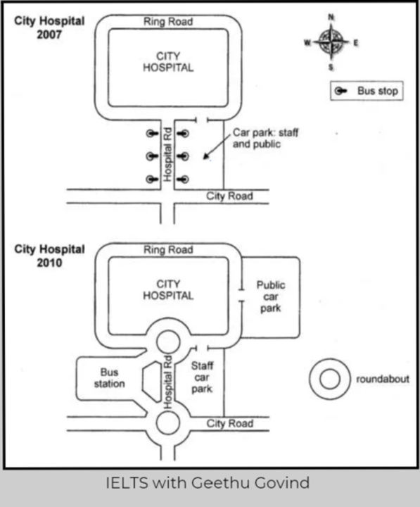
The two maps below show road access to a city hospital in 2007 and 2010. Summarise the information by selecting and reporting the main features, and make comparisons where relevant

The two maps show the changes made to access roads and facilities for travelers to City Hospital from 2007 to 2010. The city hospital has a Ring Road going around it, which is connected to the Hospital Road to the south of the hospital. The Hospital Road shares a junction with City Road further south of the Hospital Road.
Overall, bus stops on either side of Hospital Road were removed, and a Bus Station was built. Car Park, which was common for staff and the public, was converted to a staff-only car park, and a new parking area was allotted for the public. Additionally, the two junctions were converted into roundabouts.
Firstly, the Hospital Road had three Bus Stops on each side (east and west) in 2007. By 2010, these bus stops were removed, and a Bus Station was built west of the road.
Secondly, to the east of Hospital Road was a car park used initially by staff and visitors. However, in 2010, this parking lot was changed to be used only by staff, and a separate parking lot was introduced east of the Ring Road for public use.
Thirdly, in 2007, the two junctions, where City Road meets Hospital Road and where Hospital Road meets the Ring Road, had no roundabouts. Whereas by 2010, these two junctions were converted to roundabouts.
To sum up, the changes made to the roads and facilities improve traffic flow and increase accessibility to the hospital.
Fatal error: Uncaught Error: Undefined constant "php" in /home1/geethugovind/public_html/wp-content/themes/dhbootkit2/single.php:59 Stack trace: #0 /home1/geethugovind/public_html/wp-includes/template-loader.php(106): include() #1 /home1/geethugovind/public_html/wp-blog-header.php(19): require_once('/home1/geethugo...') #2 /home1/geethugovind/public_html/index.php(17): require('/home1/geethugo...') #3 {main} thrown in /home1/geethugovind/public_html/wp-content/themes/dhbootkit2/single.php on line 59